Novafos A/S
IT34’s SmartSurvey™ and PointView® have supplied Novafos A/S with state-of-the-art documentation data since 2019, providing the utilities company with easy access to digital scanning and huge volumes of data in a single, user-friendly interface.
Smart utilities, SmartSurvey™
IT34 developed SmartSurvey™ in close collaboration with Novafos A/S and Aarhus Vand A/S with the aim of improving a number of the utilities companies’ work processes. We call the application a small technological revolution because it can convert a simple video taken on a mobile phone into a complex 3D point cloud.
SmartSurvey™ improves the efficiency of the utilities company’s digital scanning activities, mobilising them at the same time. The application has been the trusty companion of employees of Novafos A/S for a couple of years now, and their verdict is clear: “We don’t merely get more data; we get better data.” This describes our exceedingly user-friendly application in a nutshell. It produces accurate data even though it is much faster than conventional surveys. More data. Better data. Purely and simply.
Novafos has now accumulated more than 3,000 SmartSurvey™ scans, which they can access, design and display in PointView®.
Ane Loft Mollerup, Planning & Projects, Novafos A/S:
‘Novafos benefits greatly from being able to go back and inspect our scanned wastewater infrastructure in PointView™, and we can use the application to explore the systems from the comfort of the office. For example, before setting up meters in a particularly inaccessible sewer system, we can use the scans to inspect the structure together with the meter supplier.’
Complex scans in sewers
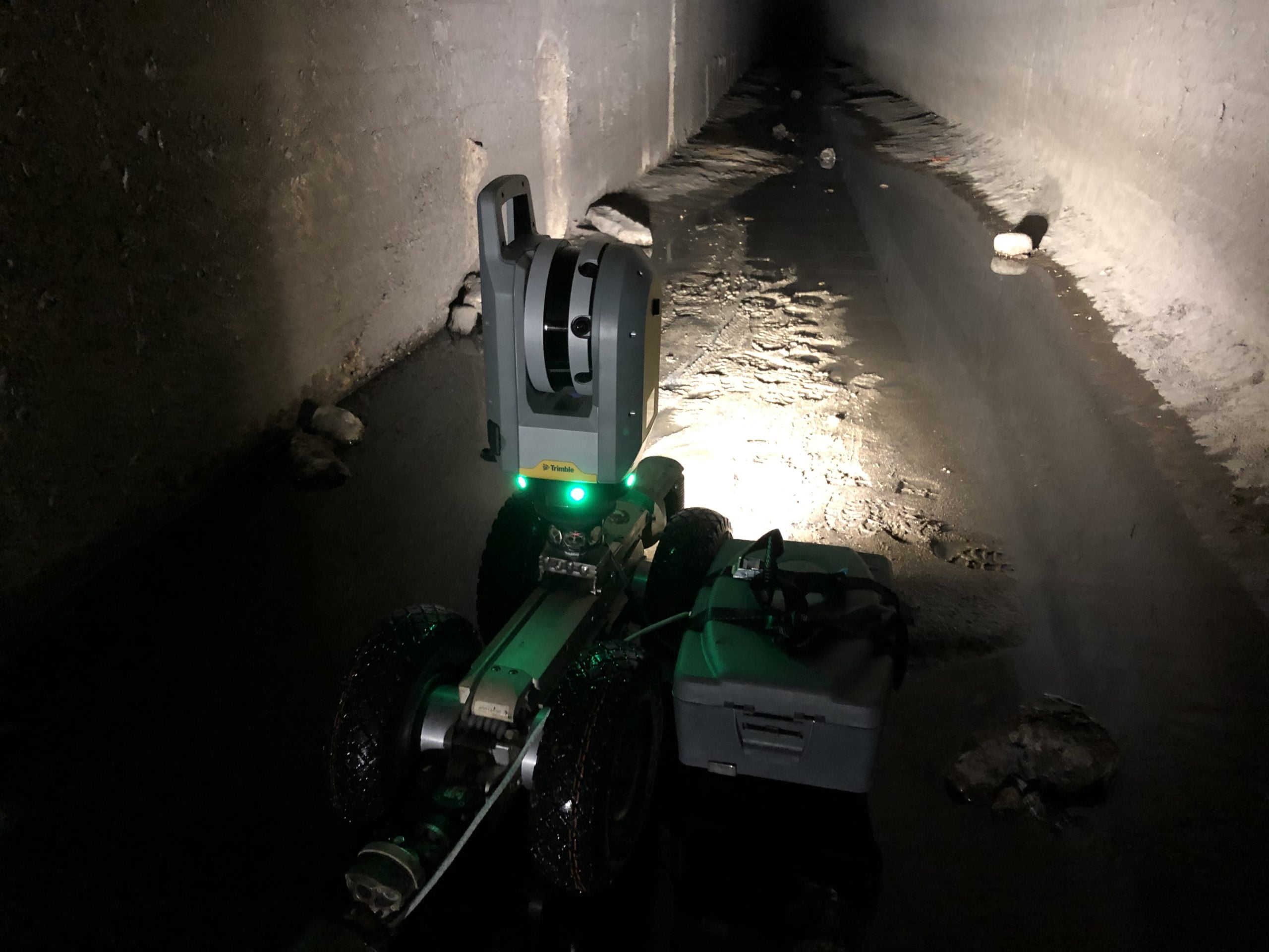
We fitted a laser scanner on the back and a prism on the front of a custom-built robot from FKSSlamson A/S and guided the robot by remote control through the entire Novafos sewer system. We were then able to inspect the sewer in more detail using the excellent point cloud displayed in PointView®.
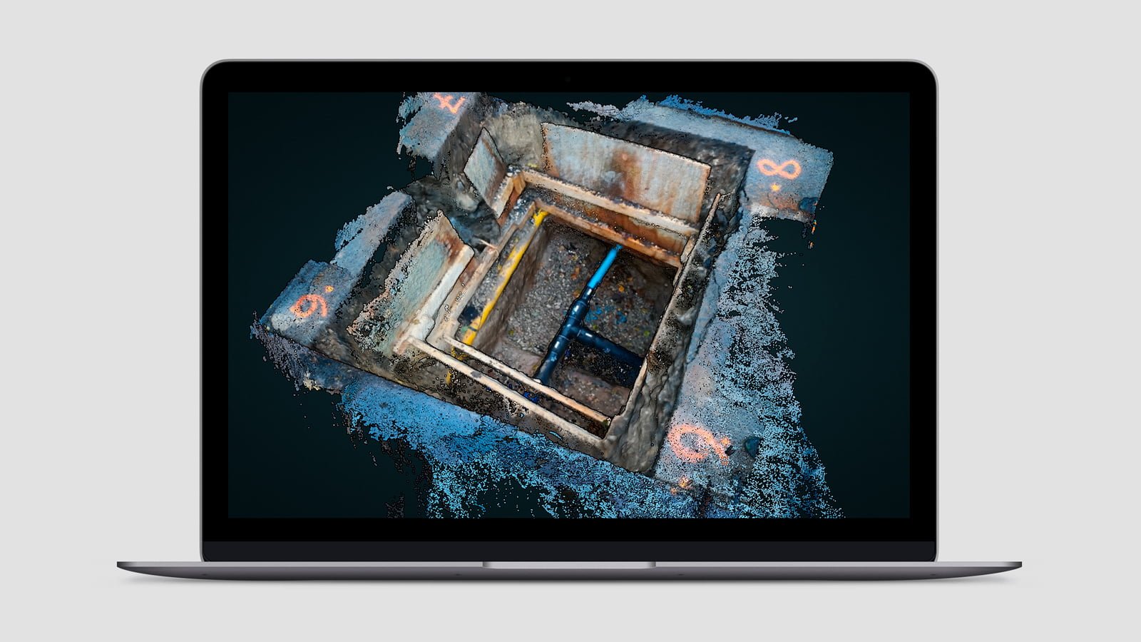
PointView®: overview, data sharing and documentation
Novafos is always more than willing to test new, innovative methods. This makes good sense, but it can also be necessary – something Novafos realised a few years ago when they needed laser scans of a sewer system to further develop its design and were not able to send engineers into the sewer for safety reasons. This was precisely the challenge that directed Novafos towards PointView® at the time.
After a complex scan of part of the sewer, the collected data were processed and displayed in PointView®, a web-based application for sharing and working in point clouds, 3D models and detailed interactive maps.
PointView® is particularly suitable for the utilities sector, where there is a need for a quick overview and practical tools on a daily basis. It is of great value to utilities companies like Novafos be able to size up a situation in a point cloud, use measurement tools, be offered documentation options and view photo documentation in a single application. What’s more, Novafos has customised the application by adding an integration solution, enabling them to access data directly from their own GIS system.
Find out more

Contact us
Would you like us to explain how your utilities company can get started using SmartSurvey™ and PointView®?
Frank Rasmussen
CTO, Business Manager
+45 7733 2240
it34@it34.com